See the top rated post in this thread. Click here

Page 1 of 3 123 LastLast
Results 1 to 10 of 21

Thread: Field shows different coordinates than actual point

  1. #1
    I could stop if I wanted to
    Join Date
    2004-09
    Posts
    262
    Login to Give a bone
    0

    Default Field shows different coordinates than actual point

    Hello everyone I am stumped.
    I created a point on a georeferenced file to get a coordinate point. The actual point when I click on it shows one value, if I add a field next to it to extract that points xy position, the values are very different.
    If there a variable I need to maybe look at? Ideally I would want both values to be the same.

    Last edited by crullier; 2015-07-30 at 02:30 AM.

  2. #2
    Certifiable AUGI Addict
    Join Date
    2001-03
    Location
    Tallahassee, FL USA
    Posts
    3,667
    Login to Give a bone
    2

    Default Re: Field shows different coordinates than actual point

    The field coordinates will always be WCS while the point properties are UCS. If you set WCS current they should match.

  3. #3
    I could stop if I wanted to
    Join Date
    2004-09
    Posts
    262
    Login to Give a bone
    0

    Default Re: Field shows different coordinates than actual point

    Tom thank you. Setting the the UCS to WCS fixes the problem !!

    How I noticed the point matches the field; at least they are both the same. How does this affect the geo-location of the CAD lines - if any?
    I am guessing that it does not ?

  4. #4
    Certified AUGI Addict cadtag's Avatar
    Join Date
    2000-12
    Location
    Cairo - no, not Illinois
    Posts
    5,069
    Login to Give a bone
    0

    Default Re: Field shows different coordinates than actual point

    well, were they drawn using the WCS or the UCS that was active? There's about more than a mile between the UCS and WCS values (if you are using feet as your unit), so i'd be suspicious of anything in that drawing. What was done to georeference it?

    Protip --
    Always have the UCSICON set to ON and NoOrigin in civil work. That way is someone changes it, you've at least got a chance of noticing.

  5. #5
    I could stop if I wanted to
    Join Date
    2004-09
    Posts
    262
    Login to Give a bone
    0

    Default Re: Field shows different coordinates than actual point

    Quote Originally Posted by cadtag View Post
    well, were they drawn using the WCS or the UCS that was active? There's about more than a mile between the UCS and WCS values (if you are using feet as your unit), so i'd be suspicious of anything in that drawing. What was done to georeference it?

    Protip --
    Always have the UCSICON set to ON and NoOrigin in civil work. That way is someone changes it, you've at least got a chance of noticing.
    I think your pro-tip applies to many types of work - or just any cad work overall. I usually like to have the UCS at the origin.

    The file is in Feet. And does land properly on the "world" based on its geo-coordinate system.

    I am have to say that I am not a civil engineer - nor do I play one of tv. I am actually an Architect trying to understand how civil files are created to make sure that when I coodinate with project with my consultants our files coninside. I actually work in Revit 90% of the time.

    I have he workflow pretty clear, but now I am trying to understand the difference between the drawings origin 0,0,0 and the "datum" being used for the coordinate system.
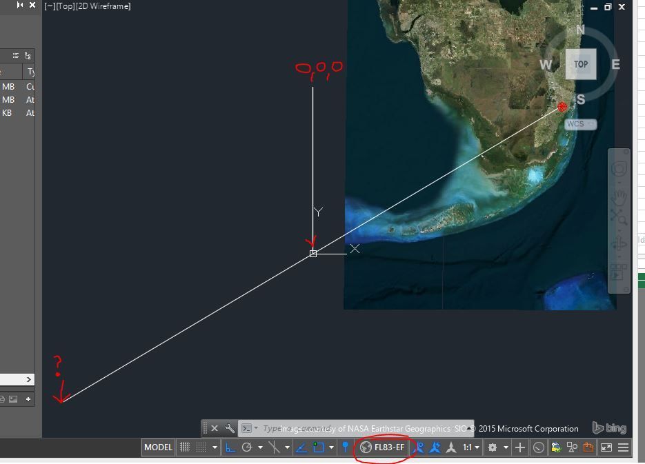
    if I back track the point, I am overshooting the drawings origin. see below.


  6. #6
    I could stop if I wanted to
    Join Date
    2004-09
    Posts
    262
    Login to Give a bone
    0

    Default Re: Field shows different coordinates than actual point

    This is the part that is very confusing to me.
    If I have a points location (autocad geometry) located at: X,Y 887259.30561347,576134.11449156
    I should be able to find its reference point by drawing a line with the "opposite coordinates" such as -887259.30561347,-576134.11449156

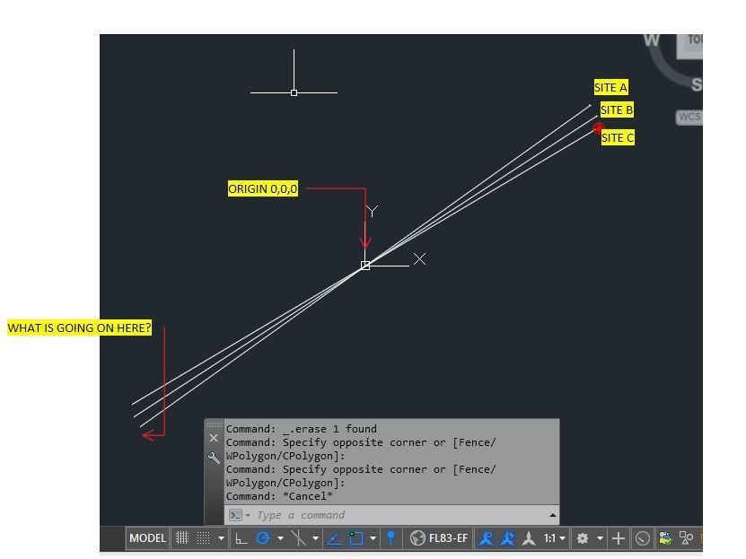
    Well so that so good. But if I insert several project which have the correct geo-referencing and pick point on each one of those sites (SITE A-C) and do the above, all line should meet on the same origin ?

    However the confusion if that all 3 lines meet at the drawings origin 0,0 however they overshoot it, and go beyond into and space and do not share a common starting point. (which is how I though these coordinate were supposed to work? Maybe I am doing something wrong - but this is precisely what I want to understand. What is going on?

    Thank you.


  7. #7
    Certifiable AUGI Addict
    Join Date
    2001-03
    Location
    Tallahassee, FL USA
    Posts
    3,667
    Login to Give a bone
    0

    Default Re: Field shows different coordinates than actual point

    That's Florida state plane 1983 coordinate system for East zone. Origin point is always set to where all coordinates in the zone are positive to keep it simple. Used to use that same zone, past 22 years I've been working in Florida state plane North zone.

  8. #8
    Certifiable AUGI Addict
    Join Date
    2001-03
    Location
    Tallahassee, FL USA
    Posts
    3,667
    Login to Give a bone
    0

    Default Re: Field shows different coordinates than actual point

    Sorry this is the first I've ever heard of this "opposite coordinates" theory… What is it you're looking for?

  9. #9
    I could stop if I wanted to
    Join Date
    2004-09
    Posts
    262
    Login to Give a bone
    0

    Default Re: Field shows different coordinates than actual point

    Quote Originally Posted by Tom Beauford View Post
    Sorry this is the first I've ever heard of this "opposite coordinates" theory… What is it you're looking for?
    not a theory, just simple reasoning. but lets keep it simple.

    In a Cartesian coordinate system, lets work on quadrant #1. (all values are pos). If I have a point on graph paper and I tell you it is at 5,10 and I ask you to find where 0,0 or it origin is, you will say that the origin that point is referencing can be found by drawing a line from the point using negative coodinates such as -5,-10

    So when I apply the principle to the different point on the CAD drawing, I see that they all have different origination coordinates. Meaning their 0,0 are not the same.
    But you seem to have answered the question for me pretty well.

    This is why I can insert xref's based on the drawings origin (0,0) and everything lines up as long as all xrefs have the same coordinate system.
    I am guessing that if I get a file from the north or west of FLA with is corresponding coordinate systems, that file will not land in it correct place in MY FL83-EL drawing.

    I appreciate your time !
    Last edited by crullier; 2015-07-30 at 06:39 PM. Reason: Edited to make my thought make sense =)

  10. #10
    I could stop if I wanted to
    Join Date
    2004-09
    Posts
    262
    Login to Give a bone
    0

    Default Re: Field shows different coordinates than actual point

    Quote Originally Posted by Tom Beauford View Post
    Sorry this is the first I've ever heard of this "opposite coordinates" theory… What is it you're looking for?
    Sorry I didn't express myself correctly, please see my edited post.

Page 1 of 3 123 LastLast

Similar Threads

  1. Field to display point coordinates relative to CURRENT ucs, not WORLD UCS
    By jpcadconsulting347236 in forum AutoCAD Fields
    Replies: 5
    Last Post: 2015-04-16, 07:27 PM
  2. Project Coordinates, Shared Coordinates, and the new Survey Point
    By Wes Macaulay in forum Revit - Platform
    Replies: 59
    Last Post: 2012-07-05, 06:20 PM
  3. Replies: 0
    Last Post: 2011-12-03, 09:13 AM
  4. Replies: 1
    Last Post: 2010-02-16, 09:30 PM
  5. Replies: 0
    Last Post: 2007-09-30, 02:56 PM

Posting Permissions

  • You may not post new threads
  • You may not post replies
  • You may not post attachments
  • You may not edit your posts
  •